Monday, April 20, 2020

CLASS 4
MY COUNTRY AND ITS LANDSCAPES (PART 6 contd.)

Good Morning Students
In our last blog we discussed Q5 to Q14. I hope you all have completed your work.
Today we will discuss QA, B and C given on page 18 of our text books.


We'll do the fill in the blanks in the notebook. 
A. Fill in the blanks.

1. India is the seventh largest country in the world in terms of its size.

2. Along with its neighbouring countries, India  is located in southern part of Asia.

3.India has 28 states and 9 union territories.


4. The summer and winter capitals of Jammu and Kashmir are Srinagar and Jammu respectively. 


5. Himalayan Mountain is the highest mountain range in the world.

B. Choose the correct answer. 
This should be done in the reader.

1. How many union territories are there in India?

a. 7             b. 9                c. 5               d. 8

2. How many states are there in India?

a. 29            b. 26               c. 28            d. 25

3. In which region is India located on the world map?

a. South Asia                          b. South-east Africa 
c. Australia                              d. Europe

4. Name the water body along the eastern coast of India.

a.Indian Ocean.                          b. Bay of Bengal                                    c. Arabian Sea.                           d. Ganga

5. Which of these is a peninsula?

a. Lakshadweep Islands                  b. Northern Plains
c. Peninsular Plateau     

 Answers: 1.b.    2.c.    3.a.    4.b.     5.c.

C. Answer the following questions.

Q.1 List the Indian states located along the coast of Arabian Sea.
Ans.  Gujarat, Maharashtra, Goa, Karnataka and Kerala.

Q.2 List the Union Territories of India and their capitals.


We have already done Q3, so no need to write it again.


Q.4 Name the countries that share their borders with India.
Ans. Pakistan, Afghanistan, China, Nepal, Bhutan, Bangladesh and Myanmar.

Q.5 Name the water bodies that surround peninsular India.
Ans. Arabian Sea in the west, Bay of Bengal in the east and Indian Ocean in the south.


That's all for today. 
We will start a new chapter in our next class so complete your work.
Stay safe. God bless!!


Thursday, April 16, 2020

CLASS 4
MY COUNTRY AND ITS LANDSCAPES (PART 6)


Good Morning Students
In our last class we learnt how to mark and label the physical divisions on the map of India.

Today we will check our answers that we have written for Questions 5 to 14.
Let's get started. 

Q5. What is a physical map?
Ans. A physical map is designed to show the physical features and landforms of a particular area.

Q6.(a) Name the six major physical divisions of India.
Ans(a) The six major physical divisions of India are:-
(i) The Northern Mountains 
(ii) The Northern Plains 
(iii) The Great Indian Desert
(iv) The Peninsular Plateau
(v) The Coastal Plains
(vi) The Islands


(b) Name the physical division in which your state lies. 
Ans(b) Our state Delhi lies in The Northern Plains.

Q7. Give two important features of the Northern Mountains.
Ans 7. The two important features of the Northern Mountains are:-
  • They are the highest mountain range in the world.
  • They form the northern border of the country and have the source of many rivers in them.

Q8. Why are the Northern Plains important for our country?
Ans 8. The Northern Plains are important for are country because the land is very fertile here and many crops are grown in this region.

Q9. What is The Great Indian Desert also known as?
Ans 9. The Great Indian Desert is also known as The Thar Desert.

Q10. What is a plateau?
Ans 10. A Plateau is an elevated (raised) land with a flat top and steep slope on at least one side. It is also called a table land.

Q11. What do you understand by the word coastal plain?
Ans 11. A coastal plain is a flat, low-lying piece of land next to the ocean.

Q12. What is an Island?
Ans 12. An Island is a piece of land that is surrounded by water from all sides.

Q13. Which island is located in the Arabian sea?
Ans 13. The Lakshadweep Islands are located in the Arabian Sea.


Q14. Where are the Andaman and Nicobar Islands located?
Ans 14. The Andaman and Nicobar Islands are located in the Bay of Bengal.

That's all for today. Do check your answers.
We will discuss the exercises on pg 18 in our next blog.
Stay safe. God bless!!


CLASS 4
MY COUNTRY AND ITS LANDSCAPE (PART 5)

Good Morning Students.
Welcome to the Social Studies class.
I hope you have revised and written all the question and answers in your notebook.

Today we will learn how to label the six physical features on a Physical map of India.

At the end of the lesson, you will be able to:- 
  •  recall some of the varied landforms which form the diverse landscape of India.
  •  label the physical divisions of India.
  •  interpret a given map (match the colour scheme with the corresponding physical features.


Now carefully look at the map of India given below. It shows the physical features/ divisions of our country.  Keeping this in mind, we will learn to do a bit of  map work today. 

   The  photocopied physical map of India with its physical demarcations will be given to you, once the school reopens.  But for now you will practice at home looking at the blog lessons.


GIVEN BELOW IS AN OUTLINE PHYSICAL MAP OF INDIA  WITH THE PHYSICAL DEMARCATIONS . Look at it carefully. 

 Learn to label and shade all the six physical divisions  neatly. 

 Observe   and  practice  how to  draw the map key shown on the left- hand side of the map attached below:-


REMEMBER!  Only colour pencils to be used for shading. NO crayons will be allowed. 

 1. .skkm - Northern Mountains
___ _______
2.  hhhiid -  Northern Plains

3.  hhhhi -   The Great Indian Desert

4.  hhhhi - The Peninsular Plateau

 5.  hhhh - The Coastal Plains

 6.  hhhh - The Island Groups


That's all for today boys. 
Stay safe and keep smiling. 


Wednesday, April 8, 2020

CLASS 4  SST

MY COUNTRY AND ITS LANDSCAPE (PART 4)


Good Morning Students and Welcome back.

We know that India has six physical divisions namely,
  1. The Northern Mountains 
  2. The Northern Plains 
  3. The Great Indian Desert
  4. The Peninsular Plateau
  5. The Coastal Plains
  6. The Islands.
In our last class we learnt about the first three Physical divisions:- The Northern Mountains, The Northern Plains and The Great Indian Desert.

Today we will be learning about the other three Physical features of India:- The Peninsular Plateau, The Coastal Plains and The Islands.

At the end of the class, you will be able to:
  • define plateau, coast and island.
  • list the six physical divisions of India.
  • identify different landscapes in a picture.
  • describe the other three physical divisions of India.

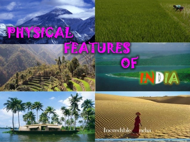
Look at the picture below. Observe that the type of landforms are very different from each other . 

                      physical features of india

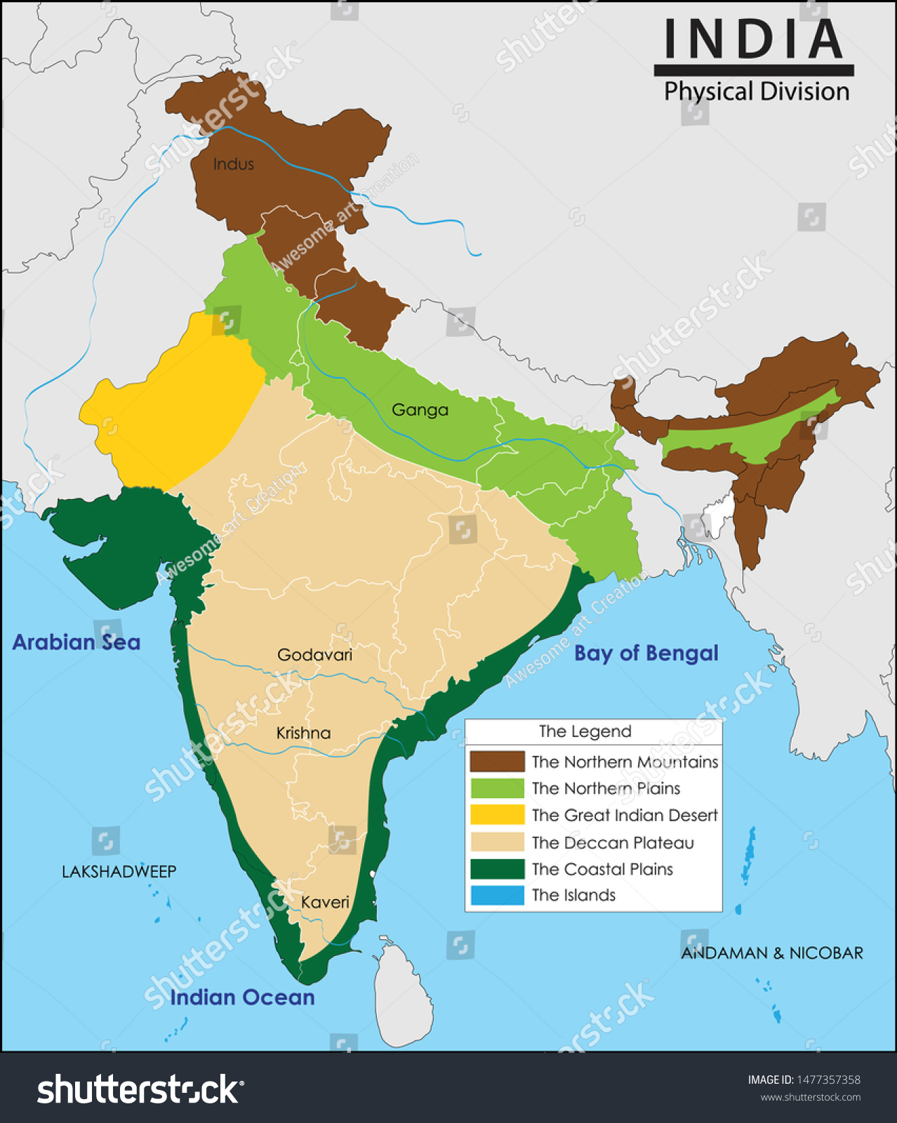
We will look at the Physical map of India given below again and try to find out which landform in the picture is related to which part in the map.

Vector Illustration India Map Physical Division Stock Vector ...

We already know that :-
  • The brown portion in the map above shows The Northern Mountains.
  • The green portion just below The Northern Mountains are The Northern Plains.
  • And the yellow portion in the map shows The great indian desert.

Now let us learn about the other three Physical divisions of India.

The Peninsular Plateau.


A Plateau is an elevated (raised) land with a flat top and steep slope on at least one side.

  • The light brown portion in the map denotes The Peninsular Plateau.
  • It lies to the south of the Northern Plains.
  • The Peninsula is inverted triangular in shape and extends till the southernmost tip of the mainland.

The Coastal Plains.


A coastal plain is a flat, low-lying piece of land next to the ocean.


  • The dark green portion denotes The Coastal Plains.
  • The Coastal Plains lie on the eastern and western coasts of the country.
  • In the west, the Coastal Plains occupy the region between the Arabian Sea and Western Ghats.
  • In the east, the Coastal Plains occupy the region between the Eastern Ghats and the Bay of Bengal.

The Islands.


An Island is a piece of land that is completely surrounded by water from all sides.

  • The blue portion in the map denotes The Islands.
  • India has an island group on its either side.
  • The Andaman and the Nicobar Islands are located in the Bay of Bengal.
  • The Lakhadweep Islands are located in the Arabian Sea.

Now let's watch a video to understand this better.


Click on the above link to learn more about the physical divisions of India.

I hope you enjoyed the video.

It's now time for homework.
Continue doing these questions in your SST notebook.

Q10. What is a plateau?
Q11. What do you understand by the word coastal plain?
Q12. What is an Island?
Q13. Which island is located in the Arabian sea?
Q14. Where are the Andaman and Nicobar Islands located?

That's all for today. 
Stay safe. God bless!!


Sunday, April 5, 2020

CLASS 4
S.ST
CH-1(Part 3)   MY COUNTRY AND ITS LANDSCAPE

Good morning boys!

In our last blog lesson, we learnt about the political divisions of our country India (States and Union Territories and their Capitals).

Today we will learn about the Physical Divisions of India.

At the end of the class, you will be able to :
  • appreciate the varied physical features of India.
  • list the six physical divisions of our country.
  • identify different landscapes in a picture.
  • describe the first three physical divisions.

The diverse physical features of India make it a beautiful and unique country. We feel proud to be born in such an awesome land!
If you want to find out which type of landform is in which part of India, you will have to look at a Physical Map of India.

A Physical map is designed to show the physical features and landforms of a particular area.

Now carefully look at the Physical map of India given below.


Now, look at the different colours used in the map above. 
Each colour denotes (meaning shows) a physical feature of the country.
You may be wondering what the term,'physical feature' means here.
Physical features here means the landforms, water bodies, etc which make up  the environment around us.
Most of you may have visited a mountainous region in India especially during the summer holidays. Isn't it?


Well, mountains are large areas of land which rise above the surrounding land. Exactly the way shown in the picture above. They have steep slopes, with pointed tops called, peaks. 
In India, the above landform  is found in many places but is most distinct (prominent) to the North .

  • The brown portion in the map given above shows (denotes) the Himalayas or the Northern Mountains..
  • They are the highest mountain range in the world.
  • They form the northern border of the country and have the source of many rivers in them.

 The picture below shows yet another landform. Can you guess what is it called?


Well the above picture is of a plain land or plains.
 Plains are huge stretches of flat land.

  •  Now,  look  at the green portion  of the map just below the Northern Mountains .It denotes(shows) the Northern Plains.
  • Many crops are grown in this region as the land is very fertile here.
  • The rivers which began their journey in the Northern mountains , now flow across this huge stretch of flat land, called the Northern Plains.

Now, let's move ahead. Below is a picture of a lonely place with no humans or vegetation (plants). Imagine our planet being so lonely one fine day! How scary that would be!  
Were you able to identify the landform shown below? 
  It's shows a picture of a desert! A dry, stretch of land (could    be both hot or cold) with little or no vegetation.


  • Now, look at the  yellow portion in the map.It shows the  Great Indian Desert, also known as The Thar Desert.
  • It spreads over the north-western part of India.
  • The sandy area is dry and receives little rainfall.

Now let's get ready for some homework.
    Continue doing the following questions in your notebook.

    Q5. What is a physical map?
    Q6. (a) Name the six major physical divisions of India.
           (b) Name the physical division in which your state lies. 
    Q7. Give two important features of the Northern Mountains.
    Q8. Why are the Northern Plains important for our country?
    Q9. What is The Great Indian Desert also known as?


    That's all for today boys. 
    Hope you enjoyed today's lesson.
    Take care. God bless!